Comparison of the versions of S. Muenster's map Polonia et Ungaria
Tetiana Gedz
Sebastian Munster’s map Polonia Et Ungaria XV Nova Tabula is one of the most famous maps depicting Eastern Europe in the middle of XVI century. At first it was published in 1540 in the Basel edition of Ptolemy's “Geography”. The name of the map Nova Tabula suggests that it belongs to the so-called “modern” maps (since the publication of “Geography” in 1482 to 27 “antique” maps “modern” maps were added, that based on contemporary ideas about the world). Due to the "revolutionary" approach to reality and high quality graphics (it was engraved by German painter Hans Holbein, Jr.), this map was printed in subsequent editions of Ptolemy's “Geography” until 1559 and in numerous editions of Munster’s “Cosmography” first published in 1544 [1]. Due to the same reasons the map was included to the famous atlas by V. Kordt [2] and modern Ukrainian publications on cartography. Differences in four available versions of this map are the subject of further consideration.
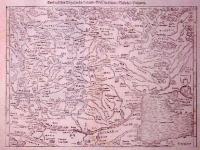
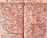
At first we will compare two Munster’s maps of different years of publication [3]. As No.1 we will denote the map Polonia Et Ungaria XV Nova Tabula [4] from the edition of Ptolemy's “Geography” (Geographia universalis vetus et nova, complectens Claudii Ptolemaei Alexandrini enarrationis libros VIII, Basel, 1540). As No.2 we will denote the map with the the same name [5], which is taken from the Munster’s “Cosmography” (La Cosmographie universelle contenant la situation de toutes les parties du monde, avec les proprietez & appartenances, Basel, 1552).
The comparison revealed that graphic elements (rivers, lakes, seas outlines, pictures of towns) on both maps coincide completely. Differences between the maps are in the text. Text part of the map No.2 was changed:
– a town in the middle flow on the left bank of Vistula River was named Soletz. This name was marked under the fragment ONIA of the word POLONIA;
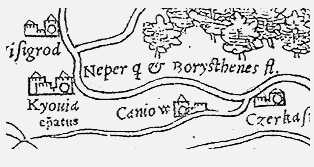
– under the symbol of Kyiv the text Kyouia epatus was appeared;
– northwest of the name TRANSILVANIA the text Septem Castra was appeared;
– under the word VALACHIA the word MAGNA was added;
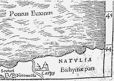
– Map No.1 contains the text Bithyni? pars on the north coast of the Black Sea in the lower right corner. On the map No. 2 this text is missing, but the name of the historical region NATVLIA (Anatolia) was appeared;

Kyiv on the map by S. Munster

The inscription “Anatolia” on the map by S. Munster
Let us consider the third version of the Munster’s map [6]. According to the commentary to the map, it is taken from the same edition of Ptolemy's “Geography” as map No.1. But it differs from both maps mentioned above. It included all the additions that were made in the map No.2 in comparison with the map No.1. The lower right corner of this map contains both texts: Bithyni? pars and NATVLIA (see Figure 2). Another difference: on the maps No.1 and 2 two adjacent areas of the Dnieper river marked with separate titles: Neper i Borysthenes. On the third map these names are combined with the sign, which obviously has a meaning “or” (Fig. 2). The comment to the third map have a reference to the Munster’s map in the atlas by V. Kordt [7]. But Munster’s map in the atlas by V. Kordt, which, in accordance with accompanying text, also is taken from the publication in 1540, is actually a fourth version, which coincides with the third in everything except the presence of two separate names of the Dnieper river, as in maps No.1 and 2.
From this we can conclude:
1. Text on the Munster’s map changes over time, and these changes not always were made as additions (remember the appearance of alternating items Bithynia and Anatolia on the map). Technology of making changes in maps, which probably was used in this cases, described in [8]. Map by S.Munster, 1540, was carved on wood. Changes to the board, on which the map was carved, were made by replacing the block, a wooden “cube”, with the block similar in size with another image or text. Judging by the number of changes in toponimic of maps, replacement of wooden patterns with blocks of text was often practiced.
2. Two of above mentioned differences relate directly to the Central Ukraine. It looks like that in the middle of XVI century S.Munster, who belonged to the most educated people in Europe, hesitated about names of Dnieper and Kyiv. Let us consider possible reasons for this.
When creating the map as a quality compilation, Munster cautiously selected the informating for it. Among the sources that he used clearly was the work by M. Miechowski Tractatus de duabus Sarmatiis, asiana et europiana, et de contentis in eis, which was published in 1517 [9]. Among the many place names that occur in it, Dnieper is mentioned as “famous Borisfen River, named by residents Dnipro (Dinepr)”. Let us note the words “named by residents”. In the upper map, “Lithuanian” part of the river twice named as Neper, and the bottom, “antique” part of it – as Borysthenes.
Historians agree that the map by S.Munster is a simplified copy of the map of South Sarmatia by Bernard Wapowski, 1526 [10]. In the album “Ukraine on the old maps…” [11], along with Munster Wapowski was even listed as the author of this map. The map by Wapowski called Dnipro as Boristenes. Ambrodgio Contarini in description of his travels, in a fragment dated 1474, used the name Dnipro [12]. So, Sebastian Munster reflected on the map the parallel using of two names of the river in modern geographic descriptions. It seems that the absense of name of Kyiv on the Munsters map, 1540, is also caused by the simultaneous use of several different namer of the city.
The peculiarity of Munster’s map is addition to names of cities of words epatus or metropol – indication that this city was the center of the Catholic episcopate or Orthodox Metropolitanate. The signature that appeared on next versions of maps is not straightforward: Kyouia epatus. Epatus, apparently, is short of Episcopatus. Thus, the signature should be translated as Kyiv episcopate. Kyiv Catholic episcopate was established by the Lithuanian Grand Duke Vytautas and existed until the middle of XVII century. The cartographer shifting emphasis from the individual name of the city to it’s function: the position of the main church in the area of administrative authority.
One reason for uncertainty in the Munster’s title for Kyiv could be simultaneous using of Turkic name Man-Kerman, which means “big city”, “great fortress”. “Letters of Turkish Sultans to Polish Kings contains this old Turkish name until the late XVI century, although in 1556 appears the transcription of the real name Kyiv [13]”. Certainly, Munster knows something about the nomadic peoples of the Eastern European steppe, because he placed on the right corner of the map the sign – tamha by Dzhuchyds [14]. This sign indicates the affiliation (before the collapse of the Golden Horde) of this territory to the ulus of Dzhuchyds, named by Dzhuchi, the eldest son of Genghis Khan. This sign once aroused the interest of V. Kordt, who gave several hypothesis in the comment to this map [15] (among them this assumption is missing).
Let us trace different names of Kyiv on maps, created before 1540.
We will start from the Fra Mauro’s world map,1459. It has three marks of Kyiv [16]. Mark on the left bank of Dnieper accompanied by text Chieuo ouer chio. At a considerable distance from the right coast, west of the inscription Wlocho (Walachia?) Chiouio city is marked. Closer to sea again on the left bank the name of the town Macharmi is readable – our well-known Man-kerman.
Than we will pay attention to the map, created under the leadership of Cardinal N.Kuzanski between 1456 and 1460 as manuscript. This map itself is not preserved, so let’s look on four maps, which are considered as its copies [17]. They are divided into two pairs of graphically similar to each other and not mutually similar maps: Hermanus-Vavassor and Rosselli-Martellus. On the first pair of maps Kyiv (Chivia) is marked, and south, in the middle of the Dnieper River, we see the city named Makromana. On the map by Rosselli Dnieper region is not pictured, but version by Martellus has the city, marked Monagramana. Remember also the fragment from Ambrogio Contarini’s diary: “May 1 we arrived in town Mahraman named also as Kyiv [18]” in the original Chio over Magraman. Not surprisingly, that on Turkish map, dated, approximately, 1490, Kyiv is also identified as Man-kerman [19]. On the map by B. Wapowski, 1526, which was based on the original data, buildings of Kyiv pictured on the right and left banks of the Dnieper with the name on the right bank Kyouia. The map of Europe by G. Zell, 1535 [20], contains the town called Kyoff.
We should pay attention to the two types of “european” names of Kyiv. The first is actually the name of the city: Kyoff, Chio (Fra Mauro, Contarini, Zell). Second – the city name as a derivative from the name of the territory: Chieuo, Chiouio, Kyouia. This word is formed on the same way as names of lands Moscovia, Transilvania, or city Comenia, that marked on all variants of maps by Kuzanski.
Finally, remember a small incident involving the map by S. Munster. There is the description of map Polonia et Ungaria, where “the right bank of the Dnieper is marked as Chiof, at the left as Kiovi. See V. Kordt, no. II, tab. XX [21]”. Indeed, this map indicates no names on the left bank opposite Kyiv. Left Bank text implies the existence of the relevant pictogram on the left bank. But graphics on Munster’s maps doesn’t change. Therefore, most likely, this record doesn’t indicate the existence of another version of Munster’s map and is only a mistake.
Literature
1. Україна на стародавніх картах. Кінець XV – перша половина XVII ст. – К., 2004. С. 28–29.
2. В. Кордт. Материалы по истории русской картографии. Вып. II. – К., 1910, табл. XX.
3. See А. Ю. Гордеев. Картография Черного и Азовского морей. Ретроспектива. До 1700 г. – К., 2006 (edition on CD).
4. Ibidem, P. 100.
5. Ibidem, P. 145.
6. Україна на стародавніх картах… Там само.
7. В. Кордт. Там само.
8. A. Baynton-Williams. .
9. Текст за виданням: Матвей Меховский Трактат о двух Сарматиях. М.–Лг., 1936.
10. Див. .
11. Україна на стародавніх картах… Там само.
12. А. Контарини. .
13. З. Абрагамович. Старая турецкая карта Украины с планом взрыва днепровских порогов и атаки турецкого флота на Киев. – Восточные источники по истории народов Юго-Восточной и Центральной Европы, Том 2. М., 1969. C. 78, карта на С. 95.
14. Samples of tamga used in portolans: И.К. Фоменко. Образ мира на старинных портоланах. Причерноморье. Конец XIII – XVII в. М., 2007, С. 356–361.
15. В. Кордт. Там само, С.12.
16. . About the Eastern Europe on Fra Mauro’s map: St. Alexandrowicz. Rozwoj kartografii Wielkiego Ksiestwa Litewskiego od XV do polowy XVIII wieku. – Poznan, 1989, S.29.
17. The History of Polish Cartography from the 15th to the 18th century by Karol Buczek. Transl.by A.Potocki. – Wroclaw&-Warszawa-Krakow, 1966, Дод. 3-6.
18. А. Контарини. Там само.
19. З. Абрагамович. Там само.
20. The History of Polish Cartography … Дод.9.
21. З. Абрагамович. Там само, С. 94.


